| |
|
Multimedia Images
Below is a list of websites that have useful maps, photographs
and other multimedia images.
Maps
- Civil Air Patrol and FWC Mapping Site - Contains georeferenced photos taken to support Deepwater Horizon Response.
- GeoPlatform.gov/gulfresponse - An online tool that provides near-real time information about the response effort. The site was developed by NOAA with the EPA, U.S. Coast Guard, and the Department of Interior.
- U.S. Fish and Wildlife Service Maps - Includes a daily status of the Deepwater Horizon oil spill by region.
- Map
of Sensitive Coastal Areas in Florida - Google Maps .kmz file (Materials developed by URS Corp., Tallahassee, FL, and Dr. Joseph Donoghue, Department of Earth, Ocean and Atmospheric Sciences, FSU. Complete interactive database at ross.urs-tally.com)
- Google
Crisis Response: Gulf of Mexico Oil Spill - A map showing the
oil spill layers (observed spill images, booms, fishing closures,
points of interest and MODIS Satellite Imagery).
Satellite and Remote Sensing Images
- MODIS and MERIS satellite RGB images showing the location and size of the oil spill - Images from the Optical Oceanography Laborator at the College of Marine
Science (University of South Florida)
- NASA
Earth Observatory - Images from the NASA Earth Observatory of
the explosion and leak at Gulf of Mexico Oil Well
- CSTARS
- Deepwater Horizon images from the Center for Southeastern Tropical Advanced Remote Sensing (CSTARS) at the University of Miami's Rosenstiel School of Marine & Atmospheric Science
- NOAA:
Latest imagery of Caribbean and Gulf of Mexico from optical sensors
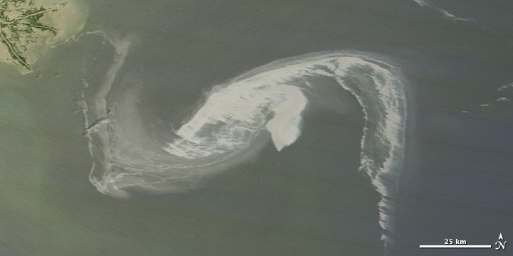
Gulf Oil Spill Creeps Towards Mississippi Delta
(acquired April 29, 2010)
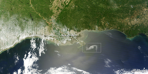
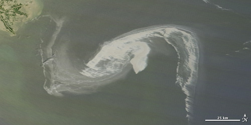
Source
for images: NASA Earth Observatory
Photo/Image Galleries
Video Images
- Formation
of Methane Hydrates on Gulf Seafloor (.wmv video, 9.5
MB) - This video shows how methane gas seeping from the
Gulf of Mexico seafloor interacts with the surrounding seawater
to form icelike crystals called methane hydrates. BP officials say
methane may have both caused the Deepwater Horizon explosion and
prevented the containment dome from being able to successfully intercept
the oil leak. Before the explosion, a methane bubble in the drill
column may have expanded and burst several seals; during the containment
attempt, methane hydrates formed on the sides of the dome, making
it buoyant and clogging up the route through which the oil was supposed
to be funneled to a surface tanker. This video footage was taken
in 2009 by a remotely operated vehicle (ROV) approximately 10 miles
from the site of the Deepwater Horizon explosion. For more information,
contact Oscar Garcia-Pineda (ogarciapineda@fsu.edu)
or Ian MacDonald (imacdonald@fsu.edu).
|
|